
Sunday, July 19, 2026
Take a deep breath, find your balance, and experience a unique yoga event at 3,000 meters.
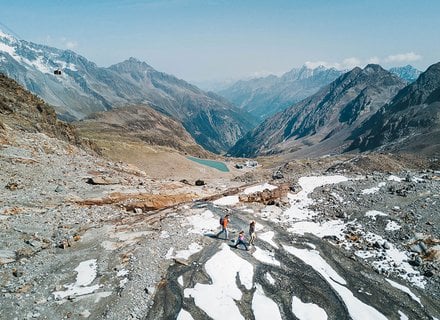
Hiking on the Stubai Glacier
Whether it's challenging summit tours for ambitious climbers or a leisurely high-altitude hike on trails suitable for children, the Stubai Valley offers one of the most beautiful hiking experiences in Tyrol, catering to every level of adventurer. Explore our Summer Hiking Map to discover all the trails around the Stubai Glacier for a memorable summer trek.


Hiking tours on the map
HIKING ROUTE 135
Upper valley station - Fernau mid-station - Dresdner Hütte (2 hrs.)
HIKING ROUTE 135A 135
Mutterberg valley station - Wilde Grub'n - Mutterberger See Lake - Niederl - Dresdner Hütte - Fernau mid-station (4.5 hrs.)
Upper valley terminal - Wilde Grub'n - Gamsgarten mountain terminal (3 hrs.)
HIKING ROUTE 102
Fernau mid-station - Eissee Lake - Eisgrat mountain terminal (2 hrs.)
Fernau mid-station - Peiljoch - Sulzenauhütte (3 hrs.)
Fernau mid-station - Egesengrat ridge (45 min.)
Dresdner Hütte loop trail (1 hour)
Refer to the hiking map for tours
The hiking trails are divided into four levels of difficulty: easy, intermediate, difficult and alpine route. Detailled information on this can be found here.

Guided hiking tours
Of course there are also guided hiking tours for the whole family.
Contact one of our experienced mountain guides.
In the winter too, you can experience the impressive glaicer world on foot. The Stubaier Gletscherbahn lifts bring you right into the world of the glaciers, where you can enjoy crisp glacier air on a marked winter hiking trail.
Contacts - hiking guides
6167 Neustift
Österreich


Important information for hikers
The Stubaier Gletscherbahn lifts are in high-alpine terrain. Unless you are in immediate proximity of the stations, you must expect high-alpine dangers. The hiking trails of the area are not part of the offer of the Stubaier Gletscherbahn lifts. The depiction of the hiking trails is not sufficient for tour planning. It is absolutely necessary to inform on the level of difficulty of the respective tour, its demands on the hikers and the trail characteristics before starting a hike. The hiking trails are not maintained by the Stubaier Gletscherbahn.The Stubaier Gletscherbahn assume no liability whatsoever for accidents happening on the hiking trails and in the alpine terrain outside of the lift stations. In case of detrimental conditions (snow, storm, fog etc.) the hiking trails are considerably more demanding of impassable! We recommend a personal tour consultancy in the mountain guide offices. .